Log Interpretation of Clastic Depositional Environments
Course Details
Being able to interpret environments of deposition using open-hole logs is a skill most geologists and engineers desire. As important as this skill is, not many publications and industry courses address this issue. The purpose of this course is to use a systematic approach that uses the process of elimination to diagnose common fluvial, shallow marine and deepwater depositional environments in well log suites such as Gamma Ray, Resistivity and Porosity and in Borehole Image and Dipmeter Logs. Borehole image logs are commonly acquired but are often under-utilized when it comes to interpreting environments of deposition. Most geoscientists and engineers are somewhat familiar with picking faults and fractures on image logs, but the same professionals will often rely on reports provided by the logging company for sedimentology and stratigraphy. This 3-day course is taught in a workshop format and after a morning lecture session, afternoons are devoted to interpretation of logs provided by the instructor. Participants are also encouraged to bring their own logs to work on (these data will not be shared with other participants and will only be reviewed by the instructor).
Who Should Attend
Geologists, Geophysicists, Petrophysicists and Engineers who are actively involved in either creating log-based cross-sections with minimal core data or create and use geomodels. The first step in facies modeling in most geomodeling software is the creation of facies logs – by the end of this course you will be able to do so for most clastic reservoirs.
Register Your Interest
Course Outline
Day 1
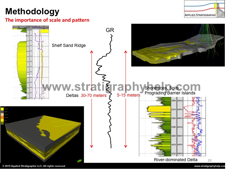
I. Methodology – can we really use well-logs to interpret environments of deposition? how far can we push our interpretation?
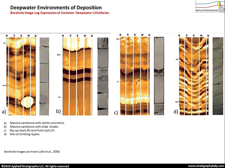
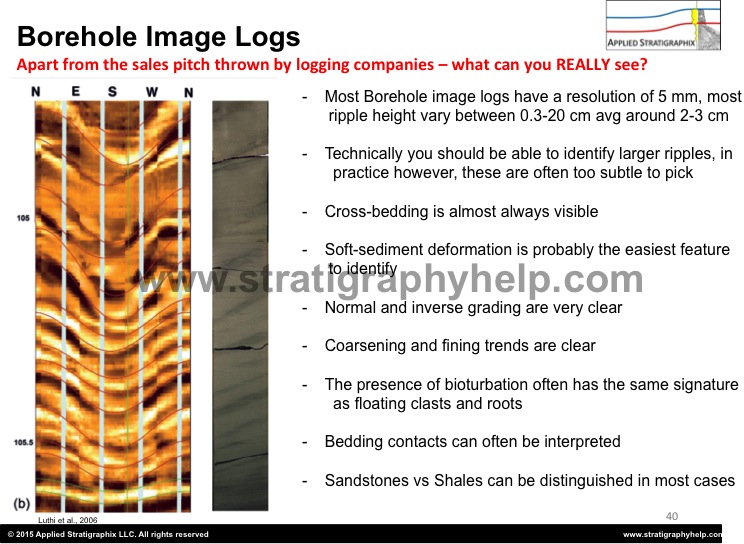
II. Primer on borehole image logs and dipmeter logs and their utility in sedimentological analyses
III. Fluvial Systems: overbank fines, crevasse splays, channel morphology, unit vs point bars in logs, calculation of channel width using borehole image logs, case-study from the Williams Fork Formation.
Day 2
Transgressive shallow marine systems: Barrier Islands, Tidal Channels, Inlets and Creeks, Estuaries and Incised Valley Systems.
Regressive systems: deltas, strand plains, prograding barrier islands and shorefaces.
Day 3
Deepwater systems: Channels, Lobes and Mass Transport Complexes, Exercise. Expression of pelagic/hemipelagic sediments, and sediment gravity flows such as debrites, turbidites and hybrid beds in borehole image logs.
How to create electrofacies?
Workshop on participant data
This course is available upon request – pricing depends on the number of participants and location.
Our headquarters are twenty minutes away from downtown Denver and half an hour from the largest core facility in the United States. Or field office in Ouray allows us quick access to world-class outcrops in Utah and New Mexico.