Structural Geology and Marine Geohazard Investigations
Course Details
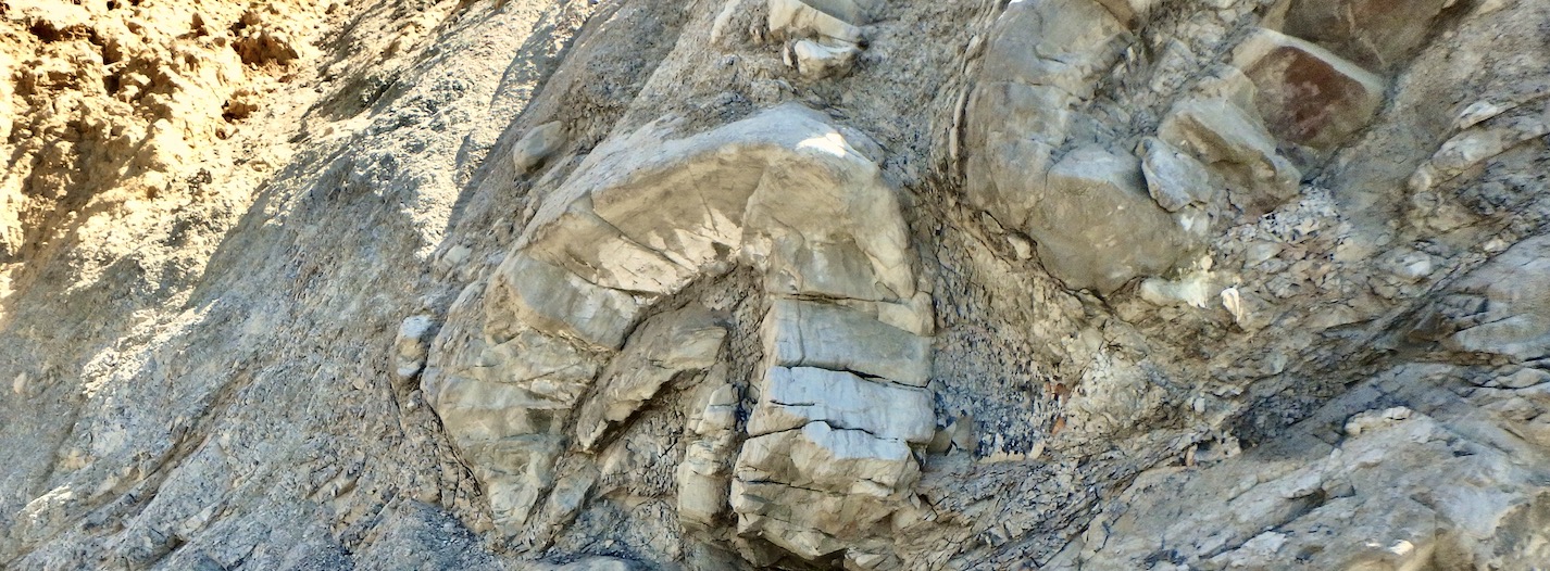
Applied Stratigraphix is offering a three day lecture-format short course on the investigation of marine geohazards for the petroleum industry from a structural geologic perspective. As the industry has extended its reach ever deeper into the marine environment, it has encountered a wide array of geohazards, most of which are related to processes unique to the marine environment. In particular, there is significant hazard from both shallow and deep geologic processes to the development of fields in regions characterized by salt and shale tectonics. This course will emphasize how structural geologic in these geologic settings directly and indirectly affect the type and level-of-activity of geohazard features encountered by marine infrastructure development.
The course will cover: The various types of geohazard environments encountered in the petroleum industry, with an emphasis on fault-related hazards and the influence of structural geologic processes on geohazard occurrence; The “Integrated Team” and “Phased Approach” to site investigations and the role of the structural geologist; The methodology, data needs, and tools of site investigations; Recognition and mapping of geohazard features; Data analysis for characterizing the location, potential magnitude, and recurrence of geohazard events; The development of conceptual geologic models for observed processes and features; Deterministic and probabilistic hazard characterization. Working with engineers to develop efficient solutions by avoidance or design.
Who Should Attend
The course is designed primarily for geologists and engineers who support the design, construction and operation of marine infrastructure. It is not necessary for attendees to be structural geologists, nor in the practice of geohazards. The course content will be of interest to all types of marine geologists including researchers and those supporting engineering projects.
Need more information?
Course Outline
Day 1
Morning: Overview of marine geohazards and their environments worldwide, with data examples from a variety of petroleum provinces.
Afternoon: A review of the different methodologies, their strengths and weaknesses (e.g., the Phased Approach; use of the Integrated Expert Team; deterministic vs probabilistic analysis); The data needs and tools for marine site investigations of structural geologic processes.
Day 2
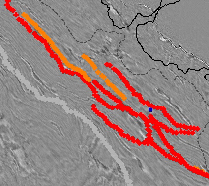
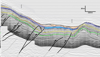
Morning: Mapping geohazards and integrating interpretations with other disciplines; Mapping and interpretation of relevant regional geologic structures and assessment of driving mechanisms.
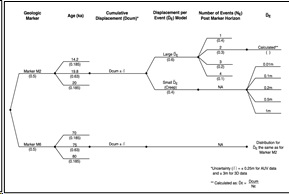
Afternoon: Data Analysis: Fault deformation hazard (faulting, tilting); Evaluate the relationships among deep geologic processes, faulting, slope failure and surficial processes. Data analysis for characterizing the location, potential magnitude, and recurrence of geohazard events;
Day 3
Morning: The importance of multiple working hypotheses and development of permissible (consistent with data) and viable (realistic) conceptual models for the structural geologic evolution of a site region; Applications of conceptual models to problem solving.
Afternoon: Practical problems to develop a site investigation plan for a proposed development; Applications to petroleum exploration and development with case histories demonstrating successes and failures from a broad range of geohazard environments and project objectives.
This course is available upon request